Lead Story // Above the fold
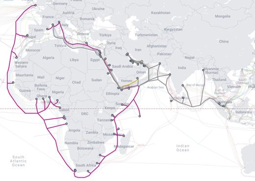
Iran, the Internet, and the Great Underwater Extension-Cord Panic
No, five cable segments in the Strait of Hormuz are not the planet’s single red extension cord.

No, five cable segments in the Strait of Hormuz are not the planet’s single red extension cord.
The storms which prompted the warning have moved out of the area. Therefore, the warning will be allowed to expire. However, gusty winds and heavy rain are still possible with these thunderstorms. A Severe Thunderstorm Watch remains in effect until 1000 PM CDT for east central Iowa. Remember, a Severe Thunderstorm Warning still remains in effect for eastern Cedar County until 630 PM CDT.
At 547 PM CDT, a severe squall line capable of producing both tornadoes and extensive straight line wind damage was located along a line extending from Wyoming to Olin to near Lisbon, moving southeast at 40 mph. HAZARD...Tornado and quarter size hail. SOURCE...Radar indicated rotation. IMPACT...Flying debris will be dangerous to those caught without shelter. Mobile homes will be damaged or destroyed. Damage to roofs, windows, and vehicles will occur. Tree damage is likely. These dangerous storms will be near... Mechanicsville, Stanwood, Wyoming, Oxford Junction, Clarence, Hale, and Oxford Mills around 550 PM CDT. Other locations in the path of these tornadic storms include Massillon Park.
At 530 PM CDT, a severe squall line capable of producing both tornadoes and extensive straight line wind damage was located along a line extending from Langworthy to near Wapsipinicon State Park to near Bertram, moving southeast at 45 mph. This storm is likely producing 70 to 80 MPH winds as well. HAZARD...Tornado and baseball size hail. SOURCE...Radar indicated rotation. IMPACT...Flying debris will be dangerous to those caught without shelter. Mobile homes will be damaged or destroyed. Damage to roofs, windows, and vehicles will occur. Tree damage is likely. These dangerous storms will be near... Mount Vernon, Lisbon, Olin, Morley, Center Junction, Central Park, Camp Courageous, and Scotch Grove around 535 PM CDT. Other locations in the path of these tornadic storms include Mechanicsville, Onslow, Hale, Stanwood, Wyoming, Clarence, Oxford Junction, Oxford Mills and Massillon Park.
At 523 PM CDT, a severe thunderstorm capable of producing a tornado was located near Langworthy, or near Anamosa, moving southeast at 45 mph. HAZARD...Tornado and baseball size hail. SOURCE...Radar indicated rotation. IMPACT...Flying debris will be dangerous to those caught without shelter. Mobile homes will be damaged or destroyed. Damage to roofs, windows, and vehicles will occur. Tree damage is likely. This dangerous storm will be near... Langworthy around 530 PM CDT.
At 522 PM CDT, a severe squall line capable of producing both tornadoes and extensive straight line wind damage was located over Linn County Fairgrounds, or 15 miles west of Anamosa, moving southeast at 55 mph. HAZARD...Tornado. SOURCE...Radar indicated rotation. IMPACT...Flying debris will be dangerous to those caught without shelter. Mobile homes will be damaged or destroyed. Damage to roofs, windows, and vehicles will occur. Tree damage is likely. These dangerous storms will be near... Whittier, Waubeek, and Matsell Bridge Natural Area around 530 PM CDT. This includes Interstate 380 between mile markers 31 and 32.
TORDVN The National Weather Service in the Quad Cities has issued a * Tornado Warning for... Northern Cedar County in east central Iowa... Jones County in east central Iowa... Southeastern Linn County in east central Iowa... * Until 615 PM CDT. * At 518 PM CDT, severe thunderstorms capable of producing both tornadoes and extensive straight line wind damage were located along a line extending from near Buck Creek to near Matsell Bridge Natural Area to near Robins, moving southeast at 45 mph. HAZARD...Tornado and baseball size hail. SOURCE...Radar indicated rotation. IMPACT...Flying debris will be dangerous to those caught without shelter. Mobile homes will be damaged or destroyed. Damage to roofs, windows, and vehicles will occur. Tree damage is likely. * These dangerous storms will be near... Anamosa, Marion, Monticello, Springville, Bertram, Martelle, Langworthy, Viola, Stone City, and Paralta around 525 PM CDT. Mount Vernon, Lisbon, Morley, Central Park, Camp Courageous, and Pictured Rocks Wildlife Area around 530 PM CDT. Olin, Center Junction, and Scotch Grove around 535 PM CDT. Other locations in the path of these tornadic storms include Mechanicsville, Onslow, Hale, Stanwood, Wyoming, Clarence, Oxford Junction, Oxford Mills and Massillon Park.
TORDVN The National Weather Service in the Quad Cities has issued a * Tornado Warning for... Northwestern Jones County in east central Iowa... Southwestern Delaware County in northeastern Iowa... Northeastern Linn County in east central Iowa... * Until 545 PM CDT. * At 502 PM CDT, a severe thunderstorm capable of producing a tornado was located over Ryan, or 11 miles south of Manchester, moving southeast at 45 mph. HAZARD...Tornado. SOURCE...Weather spotters reported funnel cloud. IMPACT...Flying debris will be dangerous to those caught without shelter. Mobile homes will be damaged or destroyed. Damage to roofs, windows, and vehicles will occur. Tree damage is likely. * This dangerous storm will be near... Coggon, Prairieburg, and Buffalo Creek Park around 505 PM CDT. Langworthy around 515 PM CDT.
At 439 PM CDT, a severe thunderstorm capable of producing a tornado was located near Winthrop, or 9 miles east of Independence, moving southeast at 45 mph. HAZARD...Tornado and golf ball size hail. SOURCE...Radar indicated rotation. IMPACT...Flying debris will be dangerous to those caught without shelter. Mobile homes will be damaged or destroyed. Damage to roofs, windows, and vehicles will occur. Tree damage is likely. Locations impacted include... Monti.
At 424 PM CDT, a confirmed tornado was located over Otterville, or near Independence, moving southeast at 45 mph. HAZARD...Damaging tornado and two inch hail. SOURCE...Emergency management confirmed tornado. IMPACT...Flying debris will be dangerous to those caught without shelter. Mobile homes will be damaged or destroyed. Damage to roofs, windows, and vehicles will occur. Tree damage is likely. This tornado will be near... Independence, Winthrop, Quasqueton, Rowley, and Buchanan County Fairgrounds around 430 PM CDT. Winthrop Golf Course and Monti around 435 PM CDT.
TORDVN The National Weather Service in the Quad Cities has issued a * Tornado Warning for... Buchanan County in northeastern Iowa... * Until 500 PM CDT. * At 420 PM CDT, a severe thunderstorm capable of producing a tornado was located over Fontana County Park, or 7 miles north of Independence, moving southeast at 45 mph. HAZARD...Tornado and hail up to two inches in diameter. SOURCE...Radar indicated rotation. IMPACT...Flying debris will be dangerous to those caught without shelter. Mobile homes will be damaged or destroyed. Damage to roofs, windows, and vehicles will occur. Tree damage is likely. * This dangerous storm will be near... Independence, Winthrop, Stanley, Jakway Park, Otterville, Wapsipinicon Golf Course, Independence Airport, and Buchanan County Fairgrounds around 425 PM CDT. Quasqueton and Winthrop Golf Course around 430 PM CDT. Rowley and Monti around 435 PM CDT.
At 413 PM CDT, a confirmed tornado was located over Fairbank, or 7 miles southwest of Oelwein, moving southeast at 40 mph. HAZARD...Damaging tornado and golf ball size hail. SOURCE...Weather spotters confirmed tornado. IMPACT...Flying debris will be dangerous to those caught without shelter. Mobile homes will be damaged or destroyed. Damage to roofs, windows, and vehicles will occur. Tree damage is likely. This tornado will be near... Hazleton, Stanley, Littleton, Otterville, Fontana County Park, and Fontana Park around 420 PM CDT.
At 407 PM CDT, a confirmed tornado was located near Fairbank, or 7 miles west of Oelwein, moving east at 35 mph. HAZARD...Damaging tornado and half dollar size hail. SOURCE...Weather spotters confirmed tornado. IMPACT...Flying debris will be dangerous to those caught without shelter. Mobile homes will be damaged or destroyed. Damage to roofs, windows, and vehicles will occur. Tree damage is likely. This tornado will be near... Oelwein around 415 PM CDT. Other locations impacted by this tornadic thunderstorm include County Roads 3 And W 13.
At 402 PM CDT, a confirmed tornado was located near Fairbank, or 12 miles west of Oelwein, moving southeast at 40 mph. HAZARD...Damaging tornado and ping pong ball size hail. SOURCE...Weather spotters confirmed tornado. IMPACT...Flying debris will be dangerous to those caught without shelter. Mobile homes will be damaged or destroyed. Damage to roofs, windows, and vehicles will occur. Tree damage is likely. This tornado will be near... Fairbank and Littleton around 405 PM CDT. Hazleton, Otterville, Fontana County Park, and Fontana Park around 410 PM CDT.
TORARX The National Weather Service in La Crosse has issued a * Tornado Warning for... Southwestern Fayette County in northeastern Iowa... * Until 430 PM CDT. * At 357 PM CDT, a confirmed tornado was located near Fairbank, or 11 miles west of Oelwein, moving east at 40 mph. HAZARD...Damaging tornado and half dollar size hail. SOURCE...Weather spotters confirmed tornado. IMPACT...Flying debris will be dangerous to those caught without shelter. Mobile homes will be damaged or destroyed. Damage to roofs, windows, and vehicles will occur. Tree damage is likely. * The tornado will be near... Fairbank around 400 PM CDT. Oelwein around 410 PM CDT. Other locations impacted by this tornadic thunderstorm include County Roads 3 And W 13.
TORDMX The National Weather Service in Des Moines has issued a * Tornado Warning for... Northeastern Black Hawk County in northeastern Iowa... Southeastern Bremer County in northeastern Iowa... * Until 415 PM CDT. * At 353 PM CDT, a confirmed tornado was located over Readlyn, or 13 miles west of Oelwein, moving east at 40 mph. HAZARD...Damaging tornado. SOURCE...Weather spotters confirmed tornado. IMPACT...Flying debris will be dangerous to those caught without shelter. Mobile homes will be damaged or destroyed. Damage to roofs, windows, and vehicles will occur. Tree damage is likely. * This tornadic thunderstorm will remain over mainly rural areas of northeastern Black Hawk and southeastern Bremer Counties, including the following locations... Readlyn.
Owyhee County has issued a civil emergency Level 2 Set Alert for the five miles surrounding Antelope Ridge Road Owyhee River Canyon to Dickshooter then south to the 45 Ranch. Contact Owyhee County at 2 0 8 4 9 5 1 2 0 5 for more information. This message was sent by the Idaho State Communications Center and is now concluded.
The Owyhee County has issued a civil emergency Level 3 Go Now Alert. From Antelope Ridge Road south to Big Springs Ranch Road south to the Owyhee River Canyon then west to the Oregon State Line. This includes Dickshooter and 45 Ranch. This message was sent by the Idaho State Communications Center and is now concluded.
At 800 PM MST, a severe thunderstorm capable of producing a tornado was located just east of Parker Canyon Lake, moving southwest at 25 mph. HAZARD...Tornado and quarter size hail. SOURCE...Radar indicated rotation. IMPACT...Flying debris will be dangerous to those caught without shelter. Mobile homes will be damaged or destroyed. Damage to roofs, windows and vehicles will occur. Tree damage is likely. Locations impacted include... Parker Canyon Lake and Ramsey Canyon Preserve. This includes Route 83 between mile markers 3 and 6.
TORTWC The National Weather Service in Tucson has issued a * Tornado Warning for... Southwestern Cochise County in southeastern Arizona... * Until 815 PM MST. * At 744 PM MST, a severe thunderstorm capable of producing a tornado was located near Sierra Vista, moving southwest at 25 mph. HAZARD...Tornado. SOURCE...Radar indicated rotation. IMPACT...Flying debris will be dangerous to those caught without shelter. Mobile homes will be damaged or destroyed. Damage to roofs, windows and vehicles will occur. Tree damage is likely. * Locations impacted include... Sierra Vista, Hereford, Parker Canyon Lake and Ramsey Canyon Preserve. This includes the following highways... Route 92 between mile markers 324 and 333. Route 83 between mile markers 3 and 6.
At 735 PM MST, a severe thunderstorm capable of producing a tornado was located over Sierra Vista, moving west at 15 mph. HAZARD...Tornado and quarter size hail. SOURCE...Radar indicated rotation. IMPACT...Flying debris will be dangerous to those caught without shelter. Mobile homes will be damaged or destroyed. Damage to roofs, windows and vehicles will occur. Tree damage is likely. Locations impacted include... Sierra Vista. This includes the following highways... Route 90 between mile markers 319 and 325. Route 92 between mile markers 322 and 327.
At 723 PM MST, a severe thunderstorm capable of producing a tornado was located about 5 miles east of Sierra Vista, moving southwest at 15 mph. HAZARD...Tornado and quarter size hail. SOURCE...Radar indicated rotation. IMPACT...Flying debris will be dangerous to those caught without shelter. Mobile homes will be damaged or destroyed. Damage to roofs, windows and vehicles will occur. Tree damage is likely. Locations impacted include... Sierra Vista. This includes the following highways... Route 90 between mile markers 319 and 333. Route 92 between mile markers 322 and 327.
This is an activation of the Endangered Missing Person Alert system. The Fort Hall Tribal Police Department is looking for Fabian Saiz a missing person who was last seen on foot in the area of Reservation Road and Swanson Road in Fort Hall Idaho and is believed to be in danger. He is a 18 year old male with black hair and brown eyes and was last seen wearing grey sweatshirt grey sweatpants and no shoes. Fabian is an autistic individual. If you have any information on the where abouts of this missing person please contact Fort Hall Tribal Police Department at 2 0 8 2 3 8 4 0 0 0 immediately.
Jackson County - Indian Creek Fire- Mandatory Evacuations ordered for residents along County Road 53/Forest Service Road 103 south of Highway 14. EVACUATE IMMEDIATELY.
At 949 PM MST, a severe thunderstorm capable of producing a tornado was located 11 miles north of Sells, moving west at 10 mph. HAZARD...Tornado and ping pong ball size hail. SOURCE...Radar indicated rotation. IMPACT...Flying debris will be dangerous to those caught without shelter. Mobile homes will be damaged or destroyed. Damage to roofs, windows and vehicles will occur. Tree damage is likely. Locations impacted include... No:ligk, San Luis - Sells District and Rincon. This includes Route 86 between mile markers 98 and 105.
 Report
No, five cable segments in the Strait of Hormuz are not the planet’s single red extension cord.
 Opinion
By this week, Gary still carried more than 20,000 outages, making up a huge share of the remaining crisis across the region. Those are the numbers. But numbers do what numbers always do: they behave. They sit there in clean rows and let people pretend this is manageable.
No, five cable segments in the Strait of Hormuz are not the planet’s single red extension cord.
By this week, Gary still carried more than 20,000 outages, making up a huge share of the remaining crisis across the region. Those are the numbers. But numbers do what numbers always do: they behave. They sit there in clean rows and let people pretend this is manageable.
A small discussion of Echoboard and the eventual rise of the platform as a way to connect and help people and situations.
 Featured Album
Open the full public photo essay.
Send story leads, corrections, documents, public records, event details, or context the editors should review. Use a safe device and network if the information is sensitive.